Field navigation becomes difficult when agricultural machinery must follow precise routes across large, irregular, or changing areas. A tractor can physically reach the correct part of a field while still drifting from its intended line, creating uneven passes or unnecessary overlap.
Accurate satellite positioning gives the machine a consistent spatial reference, while guidance software converts that reference into a route the operator or steering system can follow.
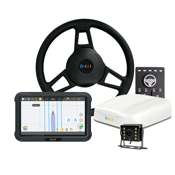
The real benefit of agricultural GPS guidance systems for precision farming comes from being able to regulate movement rather than just showing where a vehicle is. In order to assist agricultural machinery in maintaining predetermined courses, Archimedes Innovation’s AS10 Automated Steering System integrates GNSS positioning with route guiding and automated steering features.
Field Navigation Is a Path-Control Problem
Agricultural navigation involves repeated movement through a defined working area. Tillage, planting, spraying, fertilizing, ridging, and harvesting can all require machinery to travel along planned routes. A positional deviation may affect the next pass even if the machine remains generally within the field boundary.
Route consistency becomes especially relevant where adjacent passes need to remain evenly spaced. A guidance system can provide the machine with a reference line and continuously determine its position relative to that route.
The AS10 is designed to help agricultural equipment follow set paths and can assist with turning when the vehicle reaches a designated land boundary. Its published applications include tillage and soil preparation, planting and seeding, ridging, spraying and fertilizing, and harvesting.
Accuracy Comes From More Than a GPS Signal
Satellite positioning provides the geographic reference, but high-precision field navigation may require correction techniques. AS10 supports multiple GNSS constellations, including GPS, BDS, GLONASS, Galileo and QZSS. It supports RTK corrections and is capable of PPP with compatible external correction services.
The manufacturer specifies horizontal positioning of ±8 mm + 1 ppm RMS and vertical positioning of ±15 mm + 1 ppm RMS for the stated system configuration.
These capabilities illustrate why agricultural GPS guidance systems should be evaluated according to their complete positioning architecture rather than by satellite compatibility alone. Correction availability, communication methods, receiver performance, and the operating environment all affect how positioning information can be used.
AS10 supports differential communication through a 4G global network, UHF radio, and LoRa radio. That gives the system several communication pathways for receiving the information required by its positioning architecture.
How Guidance Technology Keeps the Tractor on Route?
Accurate coordinates become useful when they are connected to a guidance algorithm and steering mechanism. The system compares the machine’s current position with its planned route and generates information that helps maintain the required trajectory.
A tractor autosteer system takes this relationship one step further by linking navigation with steering control. Instead of requiring the operator to make every small steering correction manually, automated steering can respond to the calculated route and vehicle position.
AS10 is designed to follow planned routes with automated steering and high-accuracy U-turn functions. Its design also allows interaction with agricultural implements, extending navigation information beyond the tractor itself.
The distinction matters because positioning accuracy has limited practical value if the vehicle cannot translate it into controlled movement. Field navigation becomes operationally useful when positioning, guidance software, steering, and the agricultural machine work as a coordinated system.
Why Terrain and Machinery Type Matter?
Fields rarely provide identical operating conditions from one location to another. Slopes, irregular boundaries, complex field layouts, and different machine configurations can change how guidance needs to operate.
AS10 supports multiple guidance modes and is specified for complex, hilly, and irregular fields. It is also designed to work with different agricultural machine configurations, including front- and rear-wheel steering, tracked machines, articulated vehicles, transplanters, and self-propelled sprayers.
Such flexibility matters for equipment manufacturers, dealers, and agricultural operators managing mixed fleets. A guidance architecture that can accommodate different vehicle geometries can be more practical than one designed around a single tractor configuration.
Archimedes Innovation also specifies IP67 protection for the AS10 receiver, tablet, and camera, while the steering motor carries an IP65 rating. The published operating temperature range is -20°C to 70°C. These characteristics are relevant when navigation hardware is installed on machinery exposed to outdoor operating conditions.
From Navigation Data to Automated Steering
The core advantage of a tractor autosteer system is that precise navigation data becomes a steering input rather than remaining information on a screen. This can reduce the dependence on continuous manual corrections and make route following a more systematic machine function.
AS10 combines its positioning architecture with a 10.1-inch touchscreen, camera, and automated steering hardware, alongside voice‑prompt alert functions. The system is therefore structured as an operational guidance platform rather than a standalone positioning receiver.
For B2B equipment developers, this integrated approach is significant. A navigation solution needs to communicate effectively with the machine, provide suitable positioning information, and support the control behavior required by the vehicle. Hardware selection should consequently consider the complete workflow from satellite reception to steering response.
What Accurate Guidance Means in Daily Field Work?
Accurate field navigation ultimately matters because agricultural machinery must repeatedly execute physical paths with predictable positioning. Better spatial information gives guidance and steering systems a stronger reference for maintaining those paths.
Archimedes Innovation‘s AS10 demonstrates this principle through RTK-supported positioning, PPP capability, multiple GNSS constellations, route following, and automated steering functions.
The result is a navigation architecture designed around the actual movement of agricultural equipment. Rather than treating GPS as a simple location display, precision guidance uses positioning data as part of a control loop: determine where the machine is, compare that position with the planned route, and adjust movement accordingly.
For agricultural machinery manufacturers and precision-farming integrators, that distinction explains the importance of accurate guidance. Reliable positioning provides the reference; guidance software interprets it; automated steering turns it into machine movement.
Together, those elements create a more controlled approach to field navigation across planting, cultivation, spraying, harvesting, and other route-dependent operations.
